Discover Chiricahua National Monument Wilderness
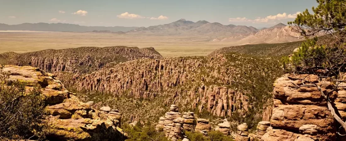
Have you ever dreamt of a place where rocks stand up like ancient statues? Chiricahua National Monument Wilderness in southeastern Arizona is just that kind of magical spot. It’s a landscape filled with incredible stone spires and a deep, compelling history. You’ll learn about what makes Chiricahua National Monument Wilderness such an amazing destination for adventurers and those eager to discover history.
This area, often called a “Wonderland of Rocks,” offers so much more than just pretty views; it is a key part of the Chiricahua mountains. Its story involves fiery volcanoes, brave Apache people, and hardworking pioneers who shaped the Faraway Ranch. For anyone who loves hiking, learning about the past, or just soaking in nature’s power, this national monument wilderness is a must-see.
We’re going to look into its geology, the people who called it home, and the best ways you can experience this monument wilderness. Think of this as your guide to an unforgettable journey through towering rock formations and quiet canyons. Get ready to discover why so many people fall in love with Chiricahua.
Table of Contents
Uncovering the Story of Chiricahua National Monument Wilderness
Every rock and canyon here tells a part of a grand story, managed with care by the National Park Service. It’s a story of Earth’s immense power and the people who found a home among these wild formations within this sky island. Understanding this history makes a visit here even more meaningful.
How the Rocks Came to Be: A Tale of Fire and Time
The incredible landscape of Chiricahua started with a giant bang, about 27 million years ago. A massive volcano, the Turkey Creek Caldera, erupted with unbelievable force. This wasn’t just any eruption; it was one of the largest in the region’s history, blanketing the land with thick layers of ash and pumice.
This material, hot and heavy, eventually cooled and fused together. It formed a type of rock called rhyolitic tuff, specifically the Rhyolite Canyon Tuff. This tuff isn’t uniformly hard, which is why it became the perfect canvas for nature’s artistry over millions of years of weathering and erosion. The careful stewardship of these natural resources allows visitors to appreciate their grandeur today.
Then, the slow, steady work of wind, rain, and frost-wedging began. These forces tirelessly wore away at the tuff, exploiting joints and weaknesses in the rock, carving out the fantastic hoodoos, balanced rocks, and tall pinnacles you see today. It’s a powerful reminder of how natural processes shape our world, creating something truly awe inspiring from volcanic chaos. Geologists study these formations to learn more about volcanic activity, ash-flow tuffs, and the power of erosion in shaping mountain ranges.
People of the Peaks: From Ancient Dwellers to Apache Land
Long before this area was a national monument, people lived here. Evidence of prehistoric groups, like the Mogollon people, includes petroglyphs etched into rock faces and artifacts found in cave shelters. They were the first to appreciate this striking land, finding shelter and sustenance among its rugged features within the Chiricahua National area.
Around the 1400s, the Chiricahua Apache people arrived, forming distinct bands that considered these mountains their heartland. They knew this place as the “Land of Standing Up Rocks.” It became their stronghold, a spiritual home, and a critical refuge. Leaders like Cochise and Geronimo are names deeply connected to these mountains and the broader Chiricahua wilderness.
They skillfully used the complex terrain to their advantage during conflicts with settlers and the U.S. Army in the late 1800s. Their story is a vital part of the monument and reflects a period of intense struggle and resilience. Although they were eventually forced from these lands, their spirit and history remain deeply embedded in the landscape, a testament to their connection with this sky island environment. The park service works to honor this Apache legacy through exhibits and information, often developed in consultation with tribal relations experts, reminding visitors of the deep human connection to this place.
Becoming a Monument: Saving a Special Place
Recognizing the importance of this area, President Calvin Coolidge designated it Chiricahua National Monument in 1924. This was a big step in protecting its geological wonders and cultural heritage for everyone, preventing these natural resources from being exploited. Later, in 1938, President Franklin D. Roosevelt expanded the monument to its current size of nearly 12,000 acres.
A significant part of the monument’s early development came from the Civilian Conservation Corps (CCC) between 1934 and 1940. Young men in the CCC built many of the roads, including the scenic drive to Massai Point, developed visitor facilities, and constructed the extensive network of hiking trails still used today. Their hard work made it possible for more people to access and appreciate this dramatic landscape, contributing greatly to future recreation opportunities.
Today, about 88% of the monument is designated as the Chiricahua National Monument Wilderness, established in 1976. This designation, under the Wilderness Act, provides the highest level of protection, making sure its natural character and primeval influences endure for future generations. The management of this wilderness area falls under the National Park Service, sometimes in coordination with the nearby Coronado National Forest for regional conservation efforts.
