Hike Pikes Peak from Crags Trailhead: A Trail Guide
You might know Pikes Peak as the majestic fourteener (a mountain exceeding 14,000 feet in elevation), but did you know there’s an approach less traveled, offering an alternative for those willing to challenge themselves? Let’s explore what it takes to hike Pikes Peak from Crags Trailhead. Unlike the popular Barr Trail, known for its steady incline and impressive mileage, this challenging, yet rewarding route offers more solitude. Starting at an elevation of 10,000 feet and culminating at Pikes Peak’s summit (14,115 feet), you’ll gain about 4,115 feet in elevation throughout the hike. This hike is worth exploring whether you are an experienced hiker searching for an alternate path or a thrill-seeking beginner wanting an extra dose of adventure.
So, lace up your boots, double-check your backpack, and prepare for the breathtaking views and adventure as we explore what makes this trail truly special. But be sure you understand your fitness level. This is an advanced hike and not recommended for novice hikers. So you can drive up if you are not up for a hike.
Table of Contents
Preparing for Your Hike Pikes Peak from Crags Trailhead Adventure
Hiking Pikes Peak is not a walk in the park. Even if you’ve hiked the mountain before via an easier trail like Barr Trail, altitude is no joke. This trail starts at a higher elevation, giving your body even less time to acclimate.
It demands proper planning and preparation. Neglecting the necessary precautions might quickly turn your adventurous spirit into an unpleasant experience. So let’s equip you with the knowledge for a truly remarkable adventure. This way you can focus on what matters most: taking in the scenery and enjoying your hike.
Understanding the Terrain and Elevation
Unlike the well-marked and heavily trafficked Barr Trail, the trail starting from Crags Trailhead is known for its rocky terrain and steep inclines. Add the high-altitude environment, which often affects even seasoned hikers, and you’ll understand why this hike requires mental and physical grit.
Packing the Essentials
Think layers for Colorado’s weather, including moisture-wicking clothing and a waterproof outer layer. Pack a map or use an app Trail Map, compass, sunscreen (the higher you go, the more important it is), a hat, sunglasses, and a headlamp.
You’ll be exerting a lot of energy, so enough food and water cannot be emphasized enough. At least three liters of water is a good benchmark. Trail mix, energy bars, and electrolyte-rich snacks can provide sustained energy for the journey. And since weather conditions can change rapidly, an emergency blanket, a whistle, and a first-aid kit are not just suggestions but necessities for a safe hike.

Hiking 14er’s or across Alpine Terrain sun protection is a must. Outdoor Hiking Apparel in Graphic Hoodies are a UPF-50 Sun Protection & a sewn in face mask.
Leaving Crags Trailhead, Hiking to Summit of 14er Pikes Peak 14,115'
Training and Acclimatization
This hike is strenuous and demanding, and preparation is more than just packing the right gear. It’s about prepping your body for what lies ahead.
Before you head out on your trip, try to acclimate yourself to the altitude by spending a few days at a higher elevation if you’re visiting or just live at a lower elevation. Engaging in regular physical activity weeks in advance will strengthen your endurance for what awaits.
Weather Considerations and When to Go
When it comes to Mother Nature in the mountains, it’s a fickle relationship. But no need to worry, because if you’re prepared for anything, there’s less that can go wrong. Summer is undoubtedly the ideal time to embark on this hike, from June through September, when the trail is accessible, and the weather is more favorable.
Aim to begin your hike before sunrise because afternoon thunderstorms are frequent.
Navigating the Trail: Step-by-Step
We’ve arrived at the exciting part. It’s time to (mentally for now) embark on the journey. From dense forests teeming with life to the windswept, above-treeline vistas that showcase nature’s grandeur, the Crags Trail doesn’t disappoint.
Here is a breakdown of what you can expect. Remember, staying mentally prepared, maintaining a steady pace, and enjoying each step will make your ascent rewarding and unforgettable.
From Trailhead to Devil’s Playground (6 Miles)
Setting off from the Crags Trailhead (elevation 10,200 feet), you’ll immerse yourself in the trail’s distinct beauty: dense forest with its towering pines and the music of nature’s symphony accompanying each step you take. Keep an eye out for wildlife like deer, marmots, and various birds who call these woods home.
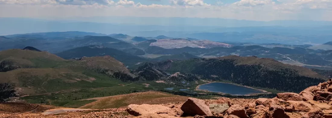
The trail is well-defined during these initial miles, meandering alongside Fourmile Creek for about half a mile. While initially, it’s a gentle ascent, as you gain elevation, expect an increase in the trail’s steepness. About 2.5 miles in you will find yourself with views of North Catamount Reservoir below you. As you reach about 11,400 feet, the scenery will transform.
Gone is the tree line; you are officially above the tree line. Embrace the challenge because about 1.5 miles later you will arrive at Devil’s Playground, a fittingly named, otherworldly landscape known for its unique rock formations. The area marks your passage into a new chapter of your adventure—Pikes Peak and its summit are in clear sight. Catch your breath while soaking in the impressive, panoramic views; you’ve earned it. You’ll soon connect with the Pikes Peak Highway.
Devil’s Playground to the Summit (1.3 Miles)
After Devil’s Playground the trail transforms from a traditional trail to more of a choose your own adventure route. The well-defined trail becomes faint at this point.
Utilize cairns—carefully placed piles of rocks—that serve as your guide. Stay focused, follow those cairns and enjoy stunning views as you hike above the Pikes Peak Highway. And keep an eye out for the Pikes Peak Cog Railway that also navigates its way along this section. You’ve made it to the top.
Hike Through Devils Playground, Hiking 14er Pikes Peak
View the complete trail to the summit. Lucky for us we ran out of battery at the summit.
At the Top
As you stand on the summit (elevation 14,115 ft.), you’re rewarded with a breathtaking panorama stretching as far as the eye can see. It’s more than just a viewpoint. It is a symbol of accomplishment, endurance, and the irresistible allure of nature’s peaks. Catch your breath, celebrate your accomplishment and take the obligatory summit photos.
Refill the water bottles its still quite a hike down. I will readily admit I was quite thirsty when I hit the campground.
Understanding Recap of the Crags Trail
Located on Pikes Peak’s northwestern side, the Crags Trail ventures through a diverse landscape, offering glimpses of natural beauty in all its forms. From dense forests with towering pines to the windswept, rocky terrain above the tree line, each step on this trail unveils a new facet of Pikes Peak’s character. This path, officially designated as Forest Service Trail 664, stretches roughly 6.8 miles one way, culminating at the peak that gives this famous fourteener its name.
Crags Trail Navigation
The beauty of the Crags Trail lies in its well-defined path, making navigation relatively easy for hikers. Beginning from the trailhead adjacent to the Crags Campground, you’ll follow along Fourmile Creek, traversing a charming wooden bridge that adds a touch of rustic charm to your adventure.
As you ascend, the trail meanders through serene forested sections punctuated by several switchbacks before gradually opening to the awe-inspiring alpine meadows that Pikes Peak is famous for.
Why Choose the Crags Trail
If conquering one of Colorado’s famed fourteeners is on your bucket list, you might wonder why you should choose the Crags Trail. One compelling reason is the promise of fewer crowds compared to the bustling Barr Trail. But there’s much more to this trail than just its relative serenity.
While the trail holds a moderate difficulty rating overall, don’t mistake it for a walk in the park. The total elevation gain of about 4,300 feet demands a good level of fitness. Remember, this trail lets you savor Pikes Peak’s splendor at a different pace, far from the more crowded trails, allowing for a richer connection with nature.
Preparing for the Crags Trail
Successfully conquering any fourteener—and the Crags Trail—demands respect for the mountain. This means more than just packing your backpack; it’s about approaching your adventure with preparedness for whatever challenges the mountain may throw your way.
Best Time to Hike the Crags Trail
Choosing the right season is crucial for an enjoyable experience on the Crags Trail. While this trail can technically be accessed year-round, summer and early fall stand out as the most favorable seasons. Ideally, aim to plan your hike between June and September for the most pleasant weather conditions.
However, late spring and early fall often reward hikers with a visual treat as wildflowers dot the path, creating bursts of color against the alpine backdrop. Always check weather forecasts before your hike and pack accordingly because conditions on Pikes Peak can change swiftly.
Essential Gear for Hiking the Crags Trail
Packing the right gear can significantly enhance your enjoyment and safety on the trail. A sturdy and comfortable backpack is crucial for carrying your essentials. You might want to consider the Osprey Sirrus 24L. Remember to include ample water to combat dehydration at higher altitudes. Staying hydrated is non-negotiable, so having a reliable water reservoir with a 2-3 liter capacity will serve you well.
Also, pack energy-dense snacks, a first-aid kit, a map, a compass, sunscreen, sunglasses, a hat, and layered clothing to tackle fluctuating weather. And remember, Colorado’s weather is known for being unpredictable, so layering is essential for adjusting to fluctuating temperatures as you gain altitude.
Acclimatizing to Altitude
The considerable elevation of Pikes Peak demands proper acclimatization. If you’re traveling from lower altitudes, give your body a day or two to acclimatize in Colorado Springs, whose elevation is about 6,000 feet, before attempting this hike. Also, be mindful of the symptoms of altitude sickness such as dizziness, headache, and nausea. If you experience these symptoms, descend immediately. Altitude sickness is real, one of your party bonged out at around 11,000 feet. They went back to ride at the trail head.
Navigating the Trail: As You Kick Up Trail Dust
Familiarizing yourself with the general trail layout can make your experience smoother. Here’s a breakdown of the Crags Trail:
| Miles | Trail Section Description |
|---|---|
| Miles 0-3 | Begin at the well-marked Crags Campground trailhead, cross the bridge, and ascend moderately through a mix of forest and open areas with scenic views. |
| Miles 3-4.5 | Reach treeline. Ascend steadily via switchbacks, with Pikes Peak coming into clearer view. |
| Miles 4.5-6 | Traverse the Devil’s Playground (a high alpine meadow). Connect with the Pikes Peak Highway briefly and encounter increased crowds, particularly tourists. |
| Miles 6-6.8 | Steeper ascent over a challenging boulder field. The trail is generally clear but can be demanding, especially at higher altitudes. |
| Summit (14,115 feet) | Enjoy sweeping panoramic views and celebrate your accomplishment. Visit the Summit House for refreshments (note: high prices) if open. |
Campsites Near the Crags Trail
If you prefer spending a night under the stars and breaking up your Crags Trail hike, you’ll be happy to know there are several campgrounds near the trailhead. This allows you to acclimatize better and soak in the beauty of the surroundings. Just a stone’s throw from the Crags Trail, you’ll find the aptly named Crags Campground. For those looking for options with more amenities, nearby Mueller State Park Campground and South Meadows Campground are good alternatives.
Alternative Routes
For those interested in exploring the area beyond their Crags Trail experience, here are a couple of noteworthy nearby trails:
- Sentinel Point via Grandview and Cheyenne Trail Loop: This loop, located near Divide, Colorado, provides a fantastic blend of challenge and scenic reward.
- Red Rock, Lion, and Section 16 Loop: Located near Woodland Park, this loop is renowned for its technical terrain and breathtaking views. It’s a longer trek. This is a longer trek and the terrian is beautiful.


