Hike Mount Elbert South and North Trails Colorado
Have you ever stood on top of a mountain, feeling like you’re on top of the world? If not, it’s time to hike Mount Elbert South and North Trails in Colorado. At 14,433 feet (or maybe even 14,440), this peak isn’t just any climb—it’s an unforgettable journey.
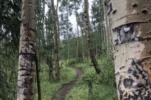
Hike to Mount Elbert summit was one of my favorites. I hiked the south trail late June, Aspens were just leafing out. A lot of mountain bikers ride and carry there bikes to the summit and ride down.
The trails offer two distinct experiences. The South Trail is less crowded but steeper; it rewards your effort with stunning forest paths that open up to sweeping alpine vistas. Meanwhile, the North Trail is more popular due to its gradual ascent along the northeast ridge.
Both routes present their own set of challenges—from false summits that’ll test your perseverance to unpredictable weather conditions typical of high altitudes. But trust me, every step is worth it for those panoramic Rocky Mountain views at the summit.
Table Of Contents:
- Hiking Mount Elbert: South and North Trails Overview
- South Mount Elbert Trail Guide
- North Mount Elbert Trail Guide
- Essential Gear and Tips for Hiking Mount Elbert
- Safety Considerations and Altitude Awareness
- Comparing the South and North Mount Elbert Trails
- FAQs in Relation to Hike Mount Elbert South and North Trails Colorado
- Conclusion of Hike Mount Elbert
- Hike the Madison River in Yellowstone Park
Hiking Mount Elbert: South and North Trails Overview
Mount Elbert, towering at 14,433 feet, is the highest point in Colorado and the second-highest peak in the contiguous United States. It’s a bucket-list hike for many, and I’ve been lucky enough to summit this behemoth via both the South and North trails. Let me tell you, the views from the top are absolutely breathtaking. You feel like you’re on top of the world, looking down on the surrounding Collegiate Peaks and the vast expanse of the Colorado Trail. But before you lace up your boots and hit the trail, there are a few key things you need to know to make your Mount Elbert hike a success.
Elevation and Distance
First off, let’s talk elevation and distance. The South Mount Elbert Trail clocks in at about 11 miles round trip, with a whopping 4,900 feet of elevation gain. The North Mount Elbert Trail is slightly shorter at 9.5 miles round trip, but still packs a punch with 4,700 feet of elevation gain. No matter which route you choose, you’re in for a strenuous day. But trust me, the sense of accomplishment when you finally reach that summit is unbeatable.
Difficulty Level
Now, I won’t sugarcoat it – hiking Mount Elbert is no walk in the park. It’s a tough climb, and the altitude can really take its toll. But with proper preparation and pacing, it’s definitely doable for most fit hikers. The South Elbert Trail is generally considered the more challenging of the two routes, with steeper grades and a bit more elevation gain. The North Elbert Trail, while still difficult, is a bit more gradual.

I have camped, fly fished, and hiked several trails and mountains. Below Mount Elbert the Arkansas River Recreation Area. I frequented this area at least 4 times a year. I really enjoyed swinging nymphs in this area of the Arkansas River. All outdoor apparel and fly fishing gear in designed and test by Outdoor Enthusiasts.
On this day like most days Hiking 14er’s and other mountain peaks. From noon till 2 pm watch for lightning. It’s a very common occurrence and kills a few people every year.
Best Time to Hike
As for the best time to hike Mount Elbert, I’d recommend July through September. This is when the trails are typically snow-free and the weather is most stable. That said, afternoon thunderstorms are a real risk in the summer months. I’ve had a few close calls myself. The key is to start early, summit before noon, and be prepared to turn back if the weather takes a turn for the worse. Lightning streaking across the sky straight over head.
I choose first weekend in July, just before the fourth. Taking the south trail was beautiful with Aspen leaves beginning to unfold.
It’s interesting how many don’t know about storms and mountain peak safety. As we were standing on the peak watching the storm and lightning roll in. A group of young ladies couldn’t understand our concern and rush to leave. So I took a few moments to explain it them and left. Across the ridge and saddle on the south trail. Lightning, hail and pelting rain pounded us till we reached tree line and cover. I can not stress enough about watch the ever changing whether conditions around as you hike, backpack, fly fish or any other sport in the outdoors.
Weather Considerations
Speaking of weather, it’s crucial to keep a close eye on the forecast leading up to your hike. Conditions can change rapidly at high elevations, and you don’t want to get caught off guard. Pack plenty of layers, including a waterproof jacket, even if the morning starts off clear. And if you see those dark clouds rolling in, don’t hesitate to bail. The mountain will still be there another day. Trust me, I’ve learned that lesson the hard way. Getting pelted with hail at 14,000 feet is an experience I wouldn’t wish on anyone. So there you have it – the key things to consider when planning your Mount Elbert hike. It’s a challenging but incredibly rewarding experience, and with the right preparation, you’ll be standing on top of Colorado before you know it.
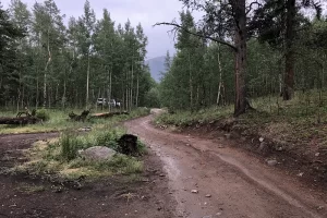
- Camping at the south trailhead for Mount Albert. I camped here before leaving at 5 am. the next morning
- Drive was through a beautiful grove of Aspen Trees
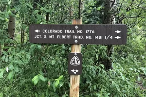
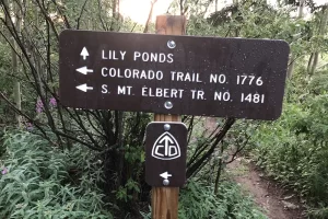
- Trailhead Sign for Mount Albert
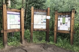
- Mount Albert information as well as National Forest. we are just above Twin Lakes, Colorado
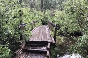
- Foot Bridge over creek at trailhead.
- Just the beginning of the wildflowers, they were amazing on this hike.
- Aspen Grove for the first mile and half was just amazing. Magical on the hike to Mount Albert Summit.
- trail to summit Mount Albert. Trail heads over to Mount Massive junction or CDT to Canada.
South Mount Elbert Trail Guide
If you’re looking for a more secluded and scenic route to the summit of Mount Elbert, the South Trail is the way to go. Don’t get me wrong, it’s still a popular hike, but it sees significantly less traffic than the North Trail.
Trail Description
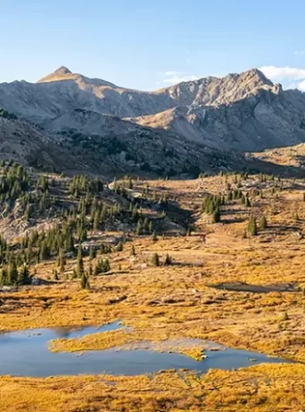
The South Mount Elbert Trail starts off meandering through dense forest, with occasional glimpses of the surrounding peaks through the trees. But once you break out above treeline, the views really open up. You’ll traverse alpine meadows blanketed in wildflowers (if you time it right), and cross a few steep gullies as you make your way up the east ridge. The trail is well-defined and easy to follow, but it’s relentless – there’s hardly a flat stretch to be found. As you near the summit, the trail gets a bit rockier and more exposed. But the views of the surrounding Sawatch Range and the Arkansas Valley below make it all worth it.
Parking and Trailhead Access
To access the South Elbert Trailhead, you’ll need to navigate some rough Forest Service roads. I’d recommend a high-clearance vehicle, especially if it’s been raining. There are a couple different parking lots and trailheads to choose from. The lower lot adds a bit of extra mileage, but the upper lot can be harder to reach. I usually opt for the upper lot, also known as the South Elbert Trailhead, to shave off some distance. Just be prepared for a bumpy ride and limited parking spots. I’ve had to park along the road a few times when the lot was full.
Route Highlights
One of my favorite parts of the South Elbert Trail is the variety of terrain and ecosystems you pass through. From dense forest to alpine tundra, it’s like hiking through a mini-tour of the Rockies. The wildflowers in July and August are absolutely stunning. I always make sure to bring my camera to capture the colorful displays. And of course, the views from the summit are unparalleled. You can see for miles in every direction, with the Collegiate Peaks and Mount Massive dominating the horizon.
Camping Options
If you want to break up the hike into two days (which I highly recommend for acclimatization purposes), there are some great camping options along the South Elbert Trail. I camped at the trailhead night before. Beautiful area. There are a few established sites near the trailhead, but my favorite spot is about halfway up at treeline. There’s a nice flat area with incredible views of the valley below. Just make sure to follow Leave No Trace principles and camp at least 100 feet from the trail and any water sources. And bear bags or canisters are a must – the marmots up there are notorious food thieves. So if you’re up for a bit of a challenge and want a more peaceful and scenic route, give the South Mount Elbert Trail a try. It’s a true Rocky Mountain gem.
Mount Elbert Trail Tip:
Ready to conquer Colorado’s highest peak? Here’s the scoop: Mount Elbert is tough but doable, with stunning views rewarding your effort. Choose between the South Trail for a scenic, quieter climb or the North Trail for a slightly easier path. Start early to beat storms and pack layers—it can get wild up there. With good prep, you’ll enjoy an unforgettable adventure.
North Mount Elbert Trail Guide
The North Mount Elbert Trail is the most popular route to the summit of Colorado’s highest peak. It’s a challenging hike, but the views are absolutely worth it. I’ve done this trail a few times now, and each time I’m blown away by the scenery. The trail starts at the North Mount Elbert Trailhead, which is easily accessible from Leadville via a well-maintained service road.
Trail Description
The North Mount Elbert Trail is about 10 miles round trip, with around 4,400 feet of elevation gain. It’s a steady climb through dense forest for the first few miles before breaking out above treeline. From there, the trail follows the mountain’s northeast ridge, passing a few false summits on the way to the top. Don’t let those false summits discourage you – keep pushing on and you’ll finally reach the true summit of Mt Elbert.
Parking and Trailhead Access
To get to the North Mount Elbert Trailhead, take Highway 24 south from Leadville for about 1.5 miles. Turn right onto County Road 9 (signs for Halfmoon Creek) and follow this road for 5 miles to the trailhead parking lot. The last mile of the road is pretty rough, but most passenger cars should be able to make it if you take it slow. There’s a large parking area at the trailhead, but it fills up quickly on summer weekends. Get there early to snag a spot.
Route Highlights
One of my favorite parts of the North Elbert Trail is the section just above treeline, where you get your first unobstructed views of the surrounding Sawatch Range. It’s a great place to stop and catch your breath before the final push to the summit. Speaking of the summit, the views from the top of Mount Elbert are unbeatable. On a clear day, you can see for miles in every direction. Make sure to give yourself plenty of time to soak it all in before starting your descent.
Camping Options
If you want to break up the hike or catch a sunrise from the summit, there are a few camping options near the North Mount Elbert Trailhead. The closest is Lakeview Campground, which is just a mile from the trailhead. There are also several dispersed camping spots along the road to the trailhead. Just make sure to follow Leave No Trace principles and camp at least 100 feet from any water sources.
Essential Gear and Tips for Hiking Mount Elbert
As with any big mountain hike, it’s important to come prepared with the right gear for Mount Elbert. The weather can change quickly at high elevations, so layers are key.
Clothing and Footwear
I always recommend wearing sturdy, broken-in hiking boots with good ankle support for Mount Elbert. The trail is rocky and uneven in spots, so you’ll want that extra stability. For clothing, think layers that you can easily put on or take off as the temperature changes. A breathable base layer, insulating mid layer, and waterproof outer layer are a good start. Don’t forget a hat, gloves, and extra socks too.
Backpack Essentials
In your backpack, make sure to pack plenty of water and snacks, as well as a few other essentials:
- Navigation tools (map, compass, GPS)
- First aid kit
- Headlamp
- Sunglasses, sunscreen, and hat
- Rain jacket or poncho
- Warm layers (fleece, puffy jacket)
It’s a long, tough hike, so don’t skimp on the snacks. I like to pack a variety of salty and sweet options to keep my energy up. Jerky and grapes is one of my favorite snacks on the trail.
Navigation Tools
Even though the North Mount Elbert Trail is well-traveled and relatively easy to follow, it’s always a good idea to carry a map and compass or GPS device. Conditions can change quickly in the mountains, and it’s important to know where you are and how to get back to the trailhead. I recommend downloading an offline map of the area before your hike, just in case you lose cell service. The Gaia GPS app is a great option for this. I do love this app.
Leave No Trace Principles
As always, it’s important to practice Leave No Trace principles when hiking Mount Elbert (or any trail). That means packing out all your trash, staying on the designated trail, and respecting wildlife. Mount Elbert is a popular hike, so it’s especially important to be mindful of your impact. Let’s all do our part to keep this beautiful mountain pristine for generations to come. Hiking Mount Elbert is a challenging but incredibly rewarding experience. With the right preparation and mindset, anyone can reach the summit of Colorado’s highest peak. Just remember to take it slow, listen to your body, and enjoy the journey. See you on the trail.
Ready to tackle Colorado’s highest peak? The North Mount Elbert Trail is your ticket, offering a challenging yet rewarding 10-mile journey. Get ready for breathtaking views above the treeline and unbeatable summit vistas. Start early, come prepared with layers and essentials, respect Leave No Trace principles, and you’re set for an unforgettable adventure.
Safety Considerations and Altitude Awareness
Mount Elbert’s high elevation and exposed terrain make it susceptible to rapidly changing weather conditions, even during the summer months. I’ve experienced this firsthand. On one of my hikes up the North Elbert Trail, the morning started off sunny and clear. But by the time I reached the higher elevations, dark clouds had rolled in and the wind picked up. I was glad I had packed a rain jacket and extra layers. It’s crucial to start early, keep an eye on the weather, and be willing to turn back if conditions deteriorate.
Weather Risks
Afternoon thunderstorms are common in the Colorado Rockies during the summer months. I always aim to reach the summit before noon to avoid getting caught in a storm. The last place you want to be during a lightning storm is above treeline on an exposed 14,000 ft peak. Check the forecast before you go and be prepared for sudden changes. Bring a rain jacket, even if the skies look clear when you start.
Altitude Sickness Prevention
At 14,433 feet (or 14,440 feet, depending on the survey), Mount Elbert’s high altitude can pose a risk for altitude sickness. I’ve seen even experienced hikers struggle with the thin air. Symptoms like headache, nausea, and dizziness can come on quickly. To minimize the risk, spend a few days acclimating at higher elevations before attempting the climb. Stay hydrated, eat regularly, and ascend slowly. If you start feeling sick, don’t push through it. Descend to a lower elevation and give your body time to adjust.
Emergency Preparedness
In case of an emergency, it’s essential to have a plan and the necessary supplies. I always carry a fully charged cell phone, but reception can be limited in the remote areas around Mount Elbert. Consider bringing a satellite communication device for added safety. Make sure someone knows your hiking plans and expected return time before setting out. If you’re overdue, they can alert the authorities. Pack a first-aid kit and know how to use it. Basic supplies like bandages, antiseptic, and pain relievers can make a big difference if you get hurt on the trail.
Wildlife Encounters
The Mount Elbert area is home to a variety of wildlife, including marmots, pikas, and occasionally mountain goats or bighorn sheep. I’ve had some close encounters with curious marmots near the summit. They’re cute, but remember that feeding them is strictly forbidden. Give all animals plenty of space and never approach them. Properly store your food and dispose of waste to avoid attracting wildlife to campsites or the trail. If you’re lucky, you might spot some mountain goats near the Lily Ponds on the South Elbert Trail or in the Mount Massive Wilderness. Bring binoculars and keep your distance to avoid disturbing them.
Comparing the South and North Mount Elbert Trails
Having hiked both the South and North Mount Elbert Trails multiple times, I’ve gotten to know their unique characteristics pretty well. While both trails ultimately lead to the same summit, they offer different experiences along the way. Here’s my take on how they compare:
Trail Difficulty
Both the South and North Mount Elbert Trails are strenuous hikes, with over 4,000 feet elevation gain in less than 5 miles. The South Elbert Trail is slightly longer at 11.6 miles roundtrip compared to the North Trail’s 9.5 miles roundtrip. But I’ve found the North Trail to be steeper and more relentless in its ascent. On the South Trail, the grade eases up in spots, giving you a chance to catch your breath. The North Trail just keeps going up and up, with very little relief. That said, I didn’t struggle as much with the altitude on the South Trail. The more gradual ascent seemed to help with acclimatization. On the North Trail, I was feeling the thin air from the get-go.
Scenery and Views
Both trails offer stunning views of the surrounding Sawatch Range, but I think the South Elbert Trail is the more scenic of the two. The South Trail passes through lush meadows and dense forest, with peek-a-boo views of the Twin Lakes along the way. Above treeline, the vistas really open up. The North Trail has a more exposed, alpine feel. You’ll catch glimpses of Turquoise Lake and Leadville in the distance, but the views are not as varied as on the South Trail. One highlight of the North Trail is the series of false summits near the top. While some hikers find them frustrating, I think they add interest to the hike. It’s fun to guess which one is the true summit.
Crowds and Solitude
The North Mount Elbert Trail is by far the more popular of the two, and it can get crowded on summer weekends. The large trailhead parking lot fills up quickly. If you’re seeking solitude, the South Elbert Trail is the better choice. I’ve hiked it on weekdays and barely seen another soul. Even on weekends, the crowds are thinner than on the North Trail. September can be a great time to hike either trail if you want to avoid the peak summer crowds. Just be prepared for colder temperatures and the possibility of snow at the higher elevations.
Accessibility
The North Mount Elbert Trailhead is easier to access, with a paved road leading right to the parking lot. The lot is large and can accommodate a good number of vehicles. Getting to the South Elbert Trailhead requires driving a few miles on a rough dirt road. A high-clearance vehicle is recommended. The parking area is much smaller, with room for only a dozen or so cars. If you’re coming from the Front Range, the North Trail is about an hour closer to drive to. That might be a factor if you’re planning a day trip. But if you’re up for a bit of adventure and don’t mind the tougher road conditions, the South Elbert Trailhead is a great option to get away from the crowds. No matter which trail you choose, summiting Mount Elbert is an incredible accomplishment. Take your time, soak in the views, and savor the feeling of standing on top of Colorado.
Always check the weather and pack for sudden changes before hiking Mount Elbert. Aim to summit by noon to dodge afternoon storms, acclimate in advance to avoid altitude sickness, have an emergency plan, respect wildlife, and choose your trail based on desired difficulty and scenery.
FAQs in Relation to Hike Mount Elbert South and North Trails Colorado
Which trail is best for Mount Elbert?
The South Mount Elbert Trail offers a balance of scenic views and manageable challenges, making it ideal for most hikers.
How long is the Mt. Elbert North trail?
The North Mount Elbert Trail stretches about 9 miles roundtrip, leading adventurers through diverse terrains to the summit.
How difficult is it to climb Mount Elbert?
Climbing Mount Elbert demands stamina due to its elevation gain but is considered moderate in difficulty among Colorado’s high peaks.
What is the most difficult hiking trail in Colorado?
In Colorado, trails like Capitol Peak are notorious for their difficulty, requiring advanced skills beyond what climbing Mt. Whitney or traversing Leadville entails.
Conclusion of Hike Mount Elbert
So there you have it—the ins and outs of hiking Mount Elbert’s South and North Trails in Colorado. Whether you crave solitude or enjoy a bustling trail experience filled with fellow hikers aiming for that same sky-high goal—Mount Elbert has something special for everyone.
The trek may be tough—with steep climbs on both routes—but reaching that true summit makes every ounce of effort worthwhile! Don’t let fear hold back what could easily become one memorable adventure story shared over campfires forevermore!
This isn’t just about bagging another 14er; it’s embracing nature at its finest while pushing personal boundaries beyond comfort zones toward incredible heights never thought possible before now…
Hike the Madison River in Yellowstone Park
Montana and Alaska offer great fly fishing experiences.

